1. Overview
Name
- Popular Name: Compass Navigation
- Alternative Names: Multi-point Compass Navigation,Guiding Lights
Intent
To present a user with several alternative destinations, and provide guidance on how to reach them, using a familiar metaphor (of a compass).
Operation: Navigation Pattern
Underlying Principle: Metaphor
2. Target
Problem
A user is at a location and has several alternative locations that they could potentially move to (perhaps to trigger some event or interaction), but they do not know how many choices they have or how to reach them.
Context
- Situation: The user is holding a physical device with location sensing technology and a method of displaying information that is complex enough to indicate direction.
- Environment: The user needs to be in a relatively open space with few obstacles, and simple paths between them and the destination.
Forces
The success of the pattern depends on:
- The simplicity of the paths.
- The number of obstacles (fewer is better).
- The sensitivity of the location technology.
- The affordance of the device display.
- The number of potential destinations (fewer is better).
- The desired complexity of the interface and interaction (suits a simpler approach).
Consequences
Weaknesses:
- W1 – Doesn’t communicate distance
- W2 – Doesn’t provide information about choices
- W3 – Doesn’t provide routing information
Strengths:
- S1 – Simple to understand
- S2 – Easy to use
- S3 – Straightforward to implement
- S4 – Robust to route changes/interference (no need to update over time)
- S5 – Can be translated into multiple representations and scales (for example, guiding lights around the edge of the whole screen)
3. Application
Solution
Sensitizer:
Participants: This is designed for a single participant.
Breakdown:
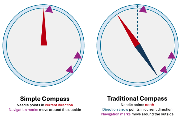
- Perimeter (normally circular)
- Markers (showing potential destinations)
- Direction indicator (optional)
- North indicator (optional)
Variations:
- Distance information: Associated with each marker addresses W1, but at the cost of S1-3
- Destination information: Associated with each marker addresses W2, but at the cost of S1-3
- Routing via a sequence of markers: Addresses W3 but at the cost of S4
Rationale
A compass is a familiar metaphor that is easily and quickly understood by users.
Implementation Details
Suggestions:
- It’s possible to use the edge of the device screen as the perimeter.
Issues:
- GPS/Magnetic inaccuracy can be problematic at short distances, and the markers may need stabilisation.
- If the markers look the same then users may lose track of which is which when they cross.
Pitfalls:
- Not clearly distinguishing between indicators and markers (e.g. users may just head north).
Impact on Immersion
The aesthetics of the compass can be adjusted to appropriate time periods or cultures in order to support cultural immersion. The device could also be referenced within narrative content (for example, as an artefact that is gifted the player) in order to increase narrative immersion.
Sensory Immersion: a compass navigation system supports the balance of attention as to successfully use it players have to attend to the device, and the real world environment, in equal measure. It also introduces embodied interaction (through the physical manipulation of the device).
Cultural Immersion: could be impacted by the aesthetics or functionality of the compass (enhanced if aligned with target cultures, detracts if misaligned).
Narrative Immersion: could be impacted by the relationship of the metaphorical device (that the compass represents) to the narrative. If it makes narrative sense for the player to have access then it enhances, if not then it detracts.
Ludic Considerations
Using the compass to track down and find points could also be a ludic activity if there was an appropriate playful context, as players need to navigate the environment, whilst using the compass to figure out where the markers are pointing to in the real world.
This will introduce a Searching or Finding Dynamic to a game.
Example
Known Uses:
Avebury CS1 uses a compass as part of its Neolithic and Middle period navigation. In the Middle period the compass appears as an 18th century compass with markers around the outside and a free floating North needle. In the Neolithic it appears as lights around the perimeter of the device (whose display has become a single rectangular rune stone). The lights are different colours in order to distinguish them.
More information is available here: https://logaculture.eu/case-study-1/
Code: Avebury CS1 is available from Github: https://github.com/LoGaCulture/LUTE
4. Supplementary Information
Biography
Version 1.0 (8/10/24) – Completed based on current Avebury Case Study 1 design documents.
Version 0.9 (2/10/24) – Initial draft developed as part of the LoGaProject WP6, investigation into design and interaction patterns.
Discussion
This is more of a missing affordance than a weakness, but as there is no map in this approach the user does not vicariously learn about their surroundings, and in particular only sees the features along the path that they choose.
Related Patterns:
- 3D Positioned Audio Navigation
Team
- Dr Jack Brett – Lead Engineer
- Dr Charlie Hargood – Academic Investigator and Architect
- Dr David Millard – Academic Investigator and Architect
- Dr Yoan Malinov – Engineer
- Dr Bob Rimmington – Qualitative Researcher
Partners
Related Resources
-
Directional Audio Navigation Cues
1. Overview Pattern Level: Sub-pattern of Audio-First Dual-Mode NavigationPrimary Phase: GuidingOne-line Summary: A navigation mechanism that plays periodic spatially positioned musical cues derived from each character’s theme, giving players directional…
-
Character-Triggered Layer Transition
1. Overview Pattern Level: High-levelPrimary Phase: Cross-phaseOne-line Summary: A layer switching mechanism that transitions the player to a different content layer when they complete an encounter with a designated portal…
-
Orientation-Based Combat
1. Overview Pattern Level: High-level Primary Phase: PresentingOne-line Summary: A challenge mechanic that uses head orientation tracking to let players evade spatially positioned threats, turning the same sensing infrastructure used for…
-
Head-Directed Target Locking
1. Overview Pattern Level: Sub-pattern of Audio-First Dual-Mode NavigationPrimary Phase: GuidingOne-line Summary: A target selection mechanism that locks onto a navigation target when the player maintains head orientation toward it…
-
Progressive Proximity Audio Zones
1. Overview Pattern Level: Sub-pattern of Audio-First Dual-Mode NavigationPrimary Phase: PresentingOne-line Summary: A zone-based audio system that transitions players from silence through character music to narrative dialogue as they physically…
-
Audio-First Dual-Mode Navigation
1. Overview Pattern Level: High-levelPrimary Phase: Cross-phaseOne-line Summary: A navigation system that automatically separates exploration and content delivery into two distinct modes, preventing navigation audio and character audio from competing…


